Here is an istat link to a geolocation data file which shows the boundaries of Italian comuni. I converted it to KML format and enhanced it with population data. I have removed the files for past years. Even though I got the boundary data from istat.it, the fidelity of the boundaries might not be exact. If you are looking at a house that is close to a comune boundary, you may want to double check with the comune to be sure it is within their boundaries.
The KML file I created can be loaded into Google Earth Pro. This will show all the comuni boundaries and will also display the comune population. There is a link below which tells where I got the population data. The population data is current as of 2023-JAN-01.
The link below is for a file in KML format, which can be imported into Google Earth Pro. Or you can use any mapping software which supports KML files. I used Google Earth Pro version 7.3.6.9345 for MacOS, but I suspect it will work the same for Google Earth Pro on other platforms. Here is how to do that.
NOTE: In previous versions of Google Earth Pro I was able to use File—>Import to load KML files, but my current version of Google Earth Pro does not seem to allow that. It may work for you.
If you load both the region boundaries file and the municipal boundaries file, you will want to load the municipal boundaries file last, that is, after you load the region boundaries. You want the municipal boundaries on top so that when you click on them you get municipal information.
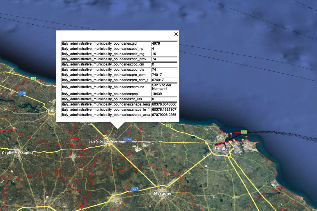
Now you can navigate around the map of Italy by scrolling and zooming in or out to find the comune of interest. Comune boundaries are outlined in red. When you click within the boundaries of a comune, a popup will appear with a table of information. The population (pop) entry is in the table just below the comune name. Here's how it looks in action:
Here is a video to show you how to use Google Earth Pro with the kml files listed below. The video has higher resolution than what is probably displayed on this web page in your browser. Right-click the video to download it and watch it in full resolution.
Note that some comune have two official names and both will be listed in the table. This is common in the Northern comuni where they often have both an Italian name (comune) and a Germanic name (comune_a).
Here is the KML file for 2023:
Here is the KML file for the region boundaries:
This could be a good resource when you are trying to figure out what comune governs a particular piece of real estate in Italy. Without this boundary information it can be tricky to know sometimes whether a house is in or out of a particular comune.
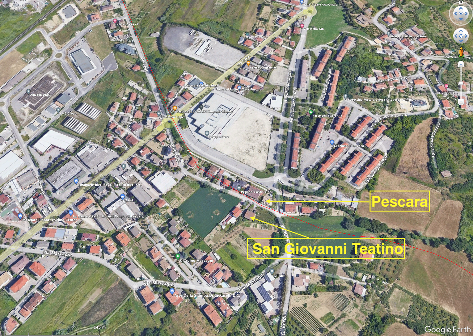
Below are two screenshots I made in Google Earth Pro after I loaded it with my boundary file. The red lines are the comune boundaries. The yellow text and arrows were added by me to illustrate that there is a fine line between 7% comuni and non-7% comuni. Pescara has too much population to qualify as a 7% comune (118,657 for 2023), so you can't make your residence there and also take advantage of the 7% tax scheme. But San Giovanni Teatino does qualify with a population of 14,331 for 2023. If you look at the arrows I made, you can see that there is a small cluster of buildings in Pescara on Via G. Verdi. But the other side of the same street is in the comune of San Giovanni Teatino. The two houses pointed by my arrows are literally across the street from each other and yet in two different comuni.
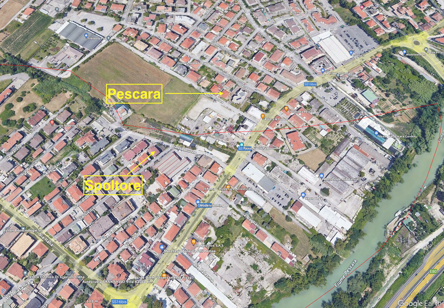
Here is another example of how close Pescara and Spoltore can be. Two houses maybe 100 meters from each other, but one is in a 7% town and the other is not.
Here is another kml file which lists healthcare facilities in southern Italy. Again, you can just drop it into Google Earth Pro and it will show you the location of many medical facilities. This kml file was uploaded by group member Pam McKinnon at our sister facebook group "Affordable Italy: Living La Dolce Vita on a Boot String". Pam says, "The data is public domain, so it is only as good as whatever was entered originally." As with all of our data posted here, please double check it before committing significant amounts of time or money.
Here is the health facility kml file:
See also for information on the population of comuni in Italy.